Thursday, October 13, 2005
 Desired lines of traffic (Click image for big pic)
The Master Plan
These images and text are taken from a report compiled by Scot & Wilson, Kirkpatric & Partners in published in 1965. (italics are mine)
Some reflection on these drawings and ideas would be prudent when imagining or allowing the second part of the M74 to be built.
Will the planners still be trying to intrigue us with such rich delights as :
"The very nature of this motorway will define the City into understandable units each with its own identity and from this it will be possible for the citizen to experience what the City means, how it functions and what it symbolises."
The residents of Govanhill and those living in the path of the proposed M74 extention know well what it symbolises and it could not be defined in the language of the propagandist who penned this.
Even in the1960s we weren't that naive to the effects of exhaust fumes on our young ones to romantisise - a motorway flitting over the top of where our kids play
(See: Elevated structure below)
"Light penetrates through the central reservation into the open space created by linking the school playing fields on either side of the motorway."
In retrospect allowing these domineering concrete paths to "define our city" was gross stupidity. To continue creating them, knowing what we know now, is culpable negligence.

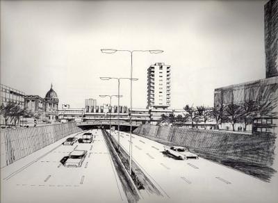
Motorway vista Carnoustie Street bridge
View northward from Carnoustie Street Bridge towards the Anderston Cross Comprehensive Development
The proposed Inner Ring roadway will provide Glasgow with a new dimension : while travelling at speeds of 50 m.p.h. the occupants of any vehicle will be able to orientate themselves quickly and easily with the City Centre by the new architectural forms and other prominent features.
The very nature of this motorway will define the City into understandÂable units each with its own identity and from this it will be possible for the citizen to experience what the City means, how it functions and what it symbolises.

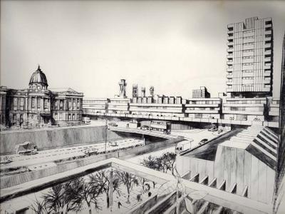
Depressed Motorway Charing Cross
In an area such as Charing Cross, where an important civic and historic building will flank the Inner Ring Road, it is essential to preserve the existing scale of development and to improve the surrounding environment by depressing the motorway.
To aid this concept, and also to give emphasis to this area of the City, it is suggested that a development should take place across the motorway adjacent to the Mitchell Library in conjunction with the erection of pedestrian bridges. This development would provide protection for pedestrians and create a visual link between both sides of the Inner Ring Road.

Depressed Motorway II
A development of this nature would give identity to this unit of the City by producing a significant impact on the skyline when viewed from the motorway.
The ultimate size of the development would depend upon the economic viability of the land uses proposed at the time this section of motorway is being built.

Elevated Motorway Laurieston/Gorbals
On the south-side of the river Clyde, due to the location of existing railway communications and difficult ground conditions, it has been necessary to elevate the motorway; this elevated section of motorway will provide many new and exciting glimpses of the City skyline.
This perspective illustrates one of the vistas looking eastward from the Laurieston/Gorbals high density residential development. The scale of the residential blocks is compatible with the height and mass of the elevated roadway.
Tall flats in the first phase of the Hutchesontown/Gorbals C.D.A. already completed will form a focal point on the axis of the east bound carriageway before it swings northward across the river.

Expressway
View of the elevated motorway from a vehicle in Eglinton Street, The continuation of this surface street will form an expressway, being one of the major routes from the City Centre.
Access to the Inner Ring Roadway from the south bound expressway is obtained by the curved ramp illustrated.
Tree and shrub planting from the river southward adjacent to the railway viaduct will produce a "parkway" effect, greatly improving the amenity of this section of the City.

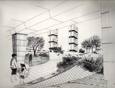
Pedestrian route
View of the pedestrian walkway underneath the elevated structure within the Laurieston/Gorbals C.D.A. : this is a typical example of how a motorway can be integrated with new development, by treating the differing architectural forms and landscaping as a whole.
Areas of open space and pedestrian routes are clearly defined by ground moulding and textured surfaces chosen to suit each particular use function.

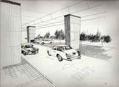
Parking Area
Typical example of a parking layout beneath an elevated section of motorway. The scale of the floorscape is reduced by the variety of surface textures used to denote the differing space functions.
Granite setts can be used in the parking bays while larger setts of differing colour may be used to determine the boundary of each bay.
Heavy cobbles, difficult to walk and drive on, are used to protect the base of the structural columns.
The edge of the hard landscape is softened wherever possible by the use of shrubs and small trees.

Areal view Townhead interchange
Aerial view of the Townhead Interchange looking north-east illusÂtrating the junction of the Springburn and Monkland Motorways with the Inner Ring Road.
The construction of this interchange will provide a unique opportunity for co-ordinating and enlarging the open space within the City.
Pedestrian and vehicular circulation is segregated throughout the interchange. Castle Street to the north is linked with the proposed schools to the west and the new Glasgow Royal Infirmary, situated on the corner site south of the Monkland Motorway.
A conscious effort has been made to improve the environment of the Cathedral precinct by depressing the Ring Road at this point.
Special attention has been given to lighting the interchange adequately. Normal street lighting techniques prove difficult at such a complex of roads and for this reason tall masts, approximately 120 feet high, are being erected in preference to a much larger number of smaller standards. These will provide a dome of light covering the entire interchange and its approach roads and will be supplemented by lighting to pedestrian walkways and bridge soffit lighting.

Typical underpass
View from the inside of a typical underpass : levels are changed gradually by the use of ramps to create interesting land forms and to make the pathway system more convenient for elderly people and mothers with perambulators.
Reflective surfaces help increase the level of daylight illumination within the underpass.
Bold clumps of planting provide a sense of enclosure.

Underpass entrance Townhead interchange
Entrance to a pedestrian area from Castle Street under sliproad; Phase 1 of the Townhead Interchange.
Stair and ramp access provide alternative means of pedestrian circulation.
Small scale planting will be introduced to give interest and shelter and, where possible, pedestrian barriers will be integrated with the landscape.

Pedestrian area Townhead interchange
Paved pedestrian area within the Townhead Interchange showing the variety of levels and textures used to create an attractive setting.
The pedestrian walkway passes underneath a sliproad to link with pedestrian circulation in the Royston C.D.A.

Pedestrian walkway
Typical walkway illustrating the principle of pedestrian and vehicular segregation within the Townhead Interchange.
From the pedestrian's point of view the planting will be arranged to soften the impact of the new road works, also to provide a sense of enclosure and protection from the movement and noise on the adjacent motorway.
Path alignment is not so direct as to be uninteresting but will contain subtle curves to match the new ground mouldings.

Elevated structure Lauureston/Gorbals
Sections through elevated motorway within the Laurieston/Gorbals C.D.A.
Light penetrates through the central reservation into the open space created by linking the school playing fields on either side of the motorway. Pedestrian footpaths link the new housing areas on either side of the motorway and provide access to covered ball and play areas.

Structure Townhead interchange
View of elevated structure within Phase 1 of the Townhead Interchange, illustrating the 9 feet by 4 feet tapering to 6 feet by 3 feet rectangular column sections supporting the 5 foot deep box beams which carry the main carriageways. The edge of the carriageway is cantilevered a distance of 7 feet from the box beams.
I will try and post more content from this tomb when I have time
Bob 3:58 AM
3 Comments:
Can you post more please? These drawings fascinate me. On one hand, the idea that Great Western Road and Maryhill Road may have been decimated by expressways is abhorent to me. On the other hand, we can still look at what might have been from a safe distance and briefly take a glimpse at what 1950's man had in mind for us.
Regards....
Regards....
The fear which we experience in the dream is only seemingly explained by diflucan the dream content.. It was this, he continued, which lifted his heart as he approached prevacid the building.. As a very recent symbol of the male genital may be mentioned the flying machine, utilization of which is justified by its relation to flying as tramadol well as occasionally by its form...
hiya!!
hopefully this message reaches you.
My name is Jacob and I represent a small group of students at the University of Strathclyde in Glasgow. We are sstudyign the M8 this year, in an effort to create recommendations to the City Council to rectify the problems that the M8 has created.
We are currently in a research stage, and we need to gather some historical information about the M8. I have read this blog and I can tell that you feel strongly about the impact of the M8.
If you would be willing to help us out by answering some questions, your input would be critical to our mission. If so, PLEASE contact me at jacob.dibble@strath.ac.uk.
thank you!
jacob
